Pink salt lakes, bounding red kangaroos and vast dry landscapes define the Mallee of north-west Victoria. But beyond the surface lies a complex story of irrigation, environmental water and fragile wetlands.
The Mallee: Australia’s overlooked transition zone
By the side of a salt lake, tinged pink by algae, an enormous red kangaroo bounds away.
This doesn’t quite feel like the true outback, but it’s certainly more sparse than the Australian bush, too.
This is the oft-ignored transition zone between the two – the Mallee.
It’s a dry landscape, with spinifex on the ground, and a smattering of ti trees. The mallee trees are bigger, but still somewhat apologetic.
There’s enough patchy vegetation to stop it being all-out desert, but it doesn’t look particularly fertile or inviting.
Murray Sunset National Park and north-west Victoria
The Murray Sunset National Park is what much of north-western Victoria would look like without human intervention.
It is the biggest National Park in the state, sprawling towards the South Australia border, and is one of the few places in Australia where grey and red kangaroos can be found alongside each other.
Peter and Jeanie Kelly, who run Murray Offroad Adventures, want to show off this often unappreciated landscape, partly to give an idea of how much the area around regional hub Mildura has been artificially altered by irrigating the Murray River.
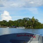
Mildura and the transformation of the Murray River
To the untrained eye, this is a land of plenty.
Grapes, almonds, stone fruit and pretty much anything else you can imagine are found growing by the roadside. Mandarins and oranges on the left, nectarines, pistachios and garlic on the right.
Mildura was set up in the 1850s with grazing licences, but it was the big irrigation scheme of the 1890s that was transformational.
Suddenly, there was agricultural land in abundance. Lots of wine is made here, and most of Australia’s table grapes come from here.
When set in contrast to the Mallee, this is extraordinary.
On the drive down, Peter and Jeanie tell the history of the area via a linked iPad and screen. This includes showing how the coastline and Murray River course have shifted over the years, moved by faultlines. Each time the river hits a fault, it deviates north.
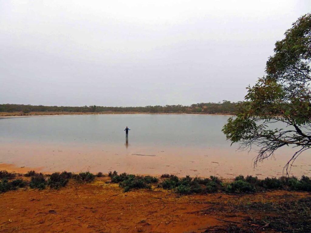
Salt lakes, drought and fire-adapted mallee trees
The Murray Sunset National Park has several former shorelines within it, but now water is a rare occurrence.
On the occasional days that it rains, tracks quickly become slippery and impassable.
For the rest of the time, it’s a strangely alluring world of emu prints across large salt pans, the occasional brightly-coloured flower, plenty of roo poo, and a wistful emptiness.
Less than 300mm of rain falls each year on the Mallee, although periods of drought are usually broken by intense floods.
Walking on one of the lakes, it feels like clay underneath, and the blackened mallee stumps give a mildly post-apocalyptic look.
Don’t feel sorry for the burned mallee trees, though – they have adapted very well to fires, with giant underground tubers that can quickly regrow when competitor species have been taken out by the fires.
Hattah-Kulkyne National Park and the Murray wetlands
The Murray Sunset’s neighbour – the Hattah-Kulkyne National Park – is a very different beast.
It’s the second stop on the Murray Offroad Adventures outing, and brings Peter’s knowledge as a former land, forest and waterways manager to the fore.
In the Hattah-Kulkyne, the feeling of transitioning to the outback has gone. This is proper bush, and riverland bush at that.
But human intervention has significantly altered things here.
There are 20 lakes, which fill intermittently, fed by Chalka Creek, an anabranch of the Murray which acts as something of an overflow pipe for Australia’s longest river.
12 of the lakes are listed under the RAMSAR convention, which protects globally significant wetlands – for migratory birds, this is a hugely important stop – and for wetlands to remain as wetlands, they require water.
Environmental water and the battle for the Murray
This is where the battle for control of the Murray’s precious flow comes in.
The agriculturalists, given the chance, would siphon off the lot to grow crops. But some has to be kept for environmental use – to sustain landscapes and ecosystems that would be killed off by allowing the crop-growers to have a free rein.
Peter explains that about half of the Murray’s flow is used for irrigation and town water supplies, and this leads to a rationing system whereby people and companies bid for water allocations.
In a dry year, these allocations get more expensive, and some will sell their allocation rather than attempting to grow anything.
“People just hear the words ‘environmental water’ and get on their high horse about it,” says Peter, but the Hattah-Kulkyne National Park is the perfect example of why it is needed.
Between 1996 and 2006, Chalka Creek was dry. The area was dying, and the wetlands were more or less dried up.
Action was needed, and a system of regulators was put in. The creek bed was lowered, and flows from the Murray were ushered in at traditional times of flood to keep the environment close to what it should be.
But what’s on show now is the natural equivalent of a medieval cathedral rebuilt after a fire – a restoration of what should be, rather than the result of nature doing its thing.
Lake Hattah, Aboriginal heritage and boundary trees
Outside Lake Hattah, which currently looks like a grassy pasture, Peter says: “This is the first lake to dry up and the first one to get full too.”
By the side of the lake is a strange-looking tree, with a series of gnarls and circles.
This is, apparently, evidence of Aboriginal presence. Indigenous groups would bend the branches to give directions and create boundary trees – trees which marked a boundary between groups, often indicating a meeting place at said boundary.
“There are too many circles on this tree for it to be accidental,” says Peter.
There are also ‘scar trees’, from which the bark would be removed to create temporary shelters or canoes.
Several groups lived along the river, and while practices and sometimes languages would be significantly different, the linking theme was the Murray.
“Each Aboriginal group tells its own version of the Dreaming story,” says Peter. “But all involve the cod being chased by a mighty hunter, carving through the landscape on the way.”
Lake Konardin and river red gum woodland
The last stop on the tour is Lake Konardin, which has grown high with Australian hollyhocks.
It is green, and verdant.
Lines on the trees show where the water got to during the 2016 floods, but it’s evidence of how much the red gums love water.
Some of the biggest trees are around 300 to 400 years old – they grow about one centimetre a year.
It offers a glorious scene of open woodland.
Kangaroos bound out from all angles – there are so many here that they have to be culled.
And a mob of emus flits amongst the hollyhock.
When you see mamma emu strut past with three little chicks, all seems right with the world – and it’s easy to forget how much of the scene is a desperately salvaged mirage.
Things to do near Murray Sunset and Hattah-Kulkyne
- Mildura: Regional food and wine hub on the Murray River, known for citrus, table grapes and wineries.
- Perry Sandhills: Wind-sculpted inland dunes just outside Mildura.
- Mungo National Park: Ancient lake beds and significant Aboriginal heritage sites in outback NSW.
- Murray River cruises: Paddle steamer and houseboat experiences along Australia’s longest river.
- Pink Lakes (Murray Sunset): Seasonal salt lakes that turn vivid shades depending on algae and light.
Murray Sunset and Hattah-Kulkyne FAQs
| Where is Murray Sunset National Park? | It is located in north-west Victoria near the South Australian border. |
| Why are the lakes pink in Murray Sunset? | The colour comes from algae that thrive in salty conditions, particularly during dry periods. |
| What is environmental water? | Environmental water is river flow allocated to sustain ecosystems, wetlands and wildlife rather than agriculture. |
| What is special about Hattah-Kulkyne National Park? | It contains 20 intermittent lakes, 12 of which are RAMSAR-listed wetlands important for migratory birds. |
| Can you see wildlife in the Mallee? | Yes, red and grey kangaroos, emus and numerous bird species are common in both parks. |
More Victoria travel
Other Victoria travel articles on Planet Whitley include:
- Why Echuca is Australia’s paddlesteamer capital.
- Why the Great Ocean Road is Australia’s classic road trip.
- Going underground at Bendigo’s Central Deborah Gold Mine.
- On the Ned Kelly Trail in Victoria’s High Country.
- Discovering Australia’s immigration history at the Bonegilla Migrant Experience.
Disclosure: This guide contains affiliate links. Book through them, and I earn a small commission at no extra cost to you.