What to see on a helicopter tour over Toronto. Discover the flight path, skyline views, and practical advice for this aerial experience.
A helicopter ride over Toronto gives a different perspective on Canada’s largest city, compressing a vast number of landmarks into a short but memorable flight.
The 7‑minute tour may be brief, but when it costs from $183 per person, it’s about as cheap as you can do a helicopter flight anywhere in the world. At that price, seeing Toronto’s skyline can be regarded as a nice bonus.
The vantage point from above turns Toronto’s skyline, waterfront, and cultural highlights into a miniature map of the city. The route is designed to showcase some of Toronto’s most recognisable sites while giving passengers a sense of its geography.
Why Toronto’s geography makes it perfect for helicopter tours
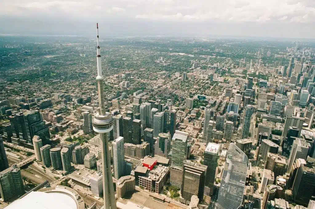
Toronto’s location on the northwestern shore of Lake Ontario creates natural visual drama that few North American cities can match. The city’s downtown core rises abruptly from the waterfront, creating a concentrated cluster of skyscrapers that stands in sharp contrast to the endless blue of the lake stretching to the horizon.
This compressed urban density – with the CN Tower as its dramatic centerpiece – means helicopter tours can capture the entire downtown core, waterfront, and island archipelago in a single sweeping view.
The city’s grid layout, interrupted by the curves of the Gardiner Expressway and the Don Valley Parkway, creates geometric patterns that only reveal themselves from above. What appears chaotic at street level – the tangle of highways, the sprawl of neighborhoods, the web of streets – suddenly makes perfect sense when viewed from 1,500 feet.
Tracing Toronto’s evolution from a helicopter
You can trace the city’s evolution outward from the original shoreline settlement, see how neighborhoods cluster around green spaces like High Park and the Don Valley, and understand why Lake Ontario has shaped every aspect of Toronto’s development.
The Toronto Islands add another visual layer. These narrow strips of land, connected by bridges and boardwalks, form a natural breakwater that creates a protected harbor. From the air, you’ll see the surprising contrast: on one side, the bustling city with its forest of towers; on the other, peaceful beaches, lagoons, and parkland where cars are banned and time seems slower.
The airport itself sits on one of these islands, meaning your helicopter tour begins and ends over water, adding to the experience.
Highlights from above
The CN Tower dominates the skyline, and from a helicopter you can truly appreciate its height compared to the surrounding buildings.
The Rogers Centre, with its retractable roof, is immediately noticeable beside it. You’ll also pass over the financial district, where glass skyscrapers reflect sunlight in patterns you simply can’t see from the street.
The route takes you along the Lake Ontario shoreline, offering a sweeping view of Toronto Islands and their beaches. The green space of High Park, the curves of the Gardiner Expressway, and the harbour’s busy ferries all appear in quick succession.
A quick but memorable trip
While seven minutes sounds short, the helicopter covers enough ground to give you a solid aerial overview. The small passenger capacity means everyone gets a window seat, and the large bubble windows make photography straightforward.
Flights operate in most weather conditions, though clear days naturally offer better visibility. Sunset flights can be particularly striking as the city lights begin to switch on.
The moment that strikes most passengers is when the helicopter banks along the waterfront and the entire skyline appears in your window at once – the CN Tower centered, the towers stepping down toward the lake, the islands spreading out below. That single view, lasting perhaps 15 seconds, captures what makes Toronto distinctive: a major global city that hasn’t lost touch with its waterfront, where nature and urban development coexist in surprisingly harmonious ways.
Practical details
Departures are from Billy Bishop Toronto City Airport, conveniently located on the Toronto Islands just offshore from downtown. Passengers must arrive around 15 minutes before departure for safety briefings. Weight limits apply for safety reasons, so check the operator’s requirements when booking.
The experience is popular, particularly at weekends and during summer, so advance booking is advisable. Headsets are provided so you can hear the pilot’s commentary over the noise of the rotors.
When to book for the best views
- Summer (June-August): Longest daylight hours, warmest weather, but can be hazy
- Autumn (September-October): Clearest skies, fall foliage visible in High Park and Don Valley
- Winter (December-February): Crisp visibility, possible snow-covered landscapes, frozen harbour
- Spring (April-May): Cherry blossoms in High Park, city coming to life
- Time of day: Golden hour (hour before sunset) offers dramatic lighting; midday provides clearest visibility for photography
More Ontario travel
Other Ontario travel articles on Planet Whitley include:
- Toronto neighbourhood guides: West Queen West.
- Why Kensington Market is Toronto’s best neighbourhood for food.
- How to get cheaper tickets for the Art Gallery of Ontario.
- How to get cheaper tickets for the Hockey Hall of Fame in Toronto.
- The way to get cheaper tickets for Casa Loma in Toronto.
- A first-time visitor’s guide to Niagara Falls, Canada.