Buderim Falls (also known as Serenity Falls) is a free, publicly accessible waterfall set within the Buderim Forest Bushland Conservation Reserve, a 45-hectare subtropical reserve on the northern edge of Buderim, on Queensland‘s Sunshine Coast. This guide covers opening hours, entry costs, parking, how to get there, trail options, accessibility, and practical tips for planning your visit.
Updated April 2026. Information in this guide reflects current Sunshine Coast Council guidance. Many other guides incorrectly suggest swimming at Buderim Falls is safe: the creek passes through urban developments and stormwater drainage before reaching the falls, and Sunshine Coast Council does not recommend swimming in the waterhole. Visitors planning to swim should note this before visiting.
Quick facts
| Detail | Information |
|---|---|
| Entry fee | Free (public reserve) |
| Opening hours | Open year-round; no set closing time (public parkland) |
| Addresses | Lower entry: Harry’s Lane, off Lindsay Road, Buderim QLD 4556. Upper entry: Quorn Close, Buderim QLD 4556. |
| Parking | Free car park at Quorn Close (upper entry). Roadside parking at Harry’s Lane (lower entry). |
| Nearest public transport | Bus to Buderim Village main street; approximately 15 minutes’ walk to the Quorn Close entrance. |
| Typical visit time | 20–45 minutes (falls only); up to 2 hours (full loop with Forest Loop circuit) |
Buderim Falls opening hours
Buderim Forest Bushland Conservation Reserve is a public space managed by Sunshine Coast Council. As a public park, it has no set entry or closing time and is accessible year-round. There are no staff on-site and no booking process required.
The falls flow year-round, but water volume varies by season. The waterfall looks particularly spectacular after rainfall, when the water from Martins Creek transforms the falls from a trickle into a strong cascade of water down the rock face. The wet season (November to March) generally produces the most volume. The falls are open during all weather conditions, but the trails become slippery after rain.
Five great things to do in the Sunshine Coast
- 🌅 Enjoy drinks as the sun goes down – on a sunset cruise along Mooloolaba’s waterways.
- 🌿 Spot wildlife in the Noosa Everglades – on the Everglades Explorer cruise.
- 🐋 On a whale-watching cruise – see migrating humpbacks from Noosa.
- 🍷 Combine food tastings with Hinterland highlights – on a scenic culinary tour.
- 🦐 On a bushtucker cruise – taste native food and learn about Aboriginal culture.
Buderim Falls entry fee and ticket prices
Entry to Buderim Falls and the Buderim Forest Bushland Conservation Reserve is free. There are no tickets, passes, or booking systems. The reserve is a public space owned and managed by Sunshine Coast Council.
Entry and pricing information was checked on the Sunshine Coast Council website and last updated in April 2026.
How to get to Buderim Falls
There are two main entry points to Buderim Falls, both accessible from Lindsay Road: the lower entry via Harry’s Lane near Harry’s Restaurant, and the upper entry point at Quorn Close.
Buderim Forest Park is roughly 7–8 km south-west of Maroochydore, or approximately 90 km north of Brisbane. From the Sunshine Motorway (Route 70), follow Mooloolaba Road into Buderim, then head down Lindsay Road. Quorn Close branches off to the right at the upper end of Buderim. By public transport, buses run to Buderim Village main street; the Quorn Close entrance is approximately a 15-minute walk from there. Most visitors arrive by car.
Parking at Buderim Falls
Free parking is available at both entry points. The Quorn Close car park (upper entry) has clearly marked spaces and is the larger and more developed of the two. Harry’s Lane is a cul-de-sac with informal roadside parking and fewer spaces, which can fill quickly on weekends and during school holidays. If visiting at a busy time, Quorn Close is the more reliable option.
How long to spend at Buderim Falls
The entire falls loop, taking time to stop, photograph, and enjoy the surroundings, takes approximately 45 minutes. Visitors entering from Harry’s Lane walk approximately one kilometre uphill to the falls; from Quorn Close it is approximately 350 metres downhill. A short additional Forest Loop circuit can be added for a longer bushland walk.
Buderim Falls can be experienced in as little as 20 minutes, though visitors could equally spend an entire day at the reserve enjoying a picnic. Allow extra time at both entry points, where picnic facilities are located.
Accessibility at Buderim Falls
Access to Buderim Falls is partially accessible for wheelchair users and pram users. From the lower entry at Harry’s Lane, visitors can begin the trail on an easy, stroller and wheelchair-accessible elevated boardwalk through the sub-tropical rainforest. As you continue, the boardwalk ends and you will need to cross bridges and rocky sections along the trail; this part is not suitable for strollers or wheelchairs.
The first 600 metres of the boardwalk through the forest from Harry’s Lane is wheelchair accessible, but wheelchair access finishes about 400 metres short of the falls. The upper entry at Quorn Close is not accessible for wheelchairs or prams, as the 350-metre track involves steep stairs. Visitors who use a wheelchair can access the boardwalk and creek environment via Harry’s Lane, but cannot reach the falls or Serenity Bridge without assistance over rocky terrain. Dogs are not permitted anywhere within the reserve.
Inside Buderim Falls: what to see and do
The elevated boardwalk starts from the Harry’s Lane entrance. This 500-metre wheelchair-accessible boardwalk is designed to allow visitors to enter the sensitive wet areas and crosses Martins Creek at several points, passing through subtropical rainforest with tall trees, ferns, and strangler figs.
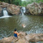
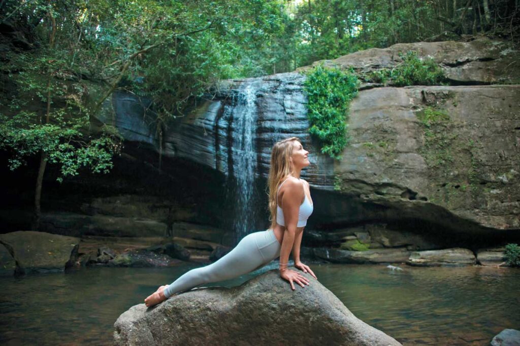
The falls (Serenity Falls) are an 8–10 metre waterfall dropping over a rock face into a shallow pool and rock chasm. Steps lead down to the water’s edge and it is possible to access the base of the falls on foot. The falls are most photogenic in low light conditions and after rainfall.
Serenity Bridge is a high-arch wooden bridge spanning the creek directly above the falls. At Serenity Bridge, visitors can take time to admire the falls and capture images of the surrounding rainforest. The bridge can be reached from either entry point and provides an elevated view over the waterfall.
The Forest Loop circuit is an optional extension beyond the falls that adds a hillier section through the upper bushland. It connects back to Quorn Close or the main trail, providing a longer walk for those wanting more time in the reserve.
Wildlife and birdlife: the falls are set in the Buderim Forest Park, on the northern side of Buderim Mountain, which is home to tall trees, dramatic strangler figs, ferns, and melodious forest birdlife such as whipbirds and catbirds.
Practical visitor tips
| Tip | Detail |
|---|---|
| Avoid peak times | The reserve is busiest on weekends and during Queensland school holidays. Arrive before 9am for quieter conditions at both entry points. |
| Wear appropriate footwear | The trail beyond the boardwalk involves creek crossings and rocky sections that become very slippery after rain. Closed-toe shoes with grip are recommended; thongs and sandals are not suitable. |
| Choose your entry point based on fitness | Quorn Close (upper) is a shorter but steeper walk to the falls (approx. 350m, steep stairs). Harry’s Lane (lower) is longer (approx. 1km) but more gradual and fully boardwalked to a point. |
| Bring everything you need | There are no cafes, kiosks, or shops inside the reserve. Bring water, snacks, and sunscreen. Toilets and barbecue facilities are available at both entry points. |
| Do not feed or disturb wildlife | The reserve is a protected natural area. Carry rubbish out and stay on marked trails to protect the sensitive rainforest environment. |
Frequently asked questions about Buderim Falls
| Question | Answer |
|---|---|
| Is Buderim Falls suitable for children? | Yes, the flat boardwalk section from Harry’s Lane is suitable for young children. The section beyond the boardwalk involves creek crossings and rocky steps; younger children can manage this with supervision, but caution is needed, particularly after rain when surfaces are slippery. |
| Do you need to book tickets in advance for Buderim Falls? | No. Entry is free and no booking is required. The reserve is a public park with no ticketing system. Visitors arrive and depart at their own pace. |
| Is Buderim Falls open on Sundays? | Yes. The reserve is open every day of the year with no set hours. Sundays tend to be among the busiest days; earlier visits are recommended to avoid crowds at the car parks. |
| Are dogs allowed at Buderim Falls? | No. Dogs are not permitted anywhere within the Buderim Forest Bushland Conservation Reserve. This applies at all times, including on leads. |
| Is it safe to swim at Buderim Falls? | Swimming is not recommended. The waterhole below the falls is fed by Martins Creek, which passes through urban developments and stormwater drains before reaching the falls. Sunshine Coast Council does not endorse swimming at this location. |
Things to do near Buderim Falls
Buderim Village is less than one kilometre from the Quorn Close entry point. The village has cafes, boutique shops, galleries, and the historic Pioneer Cottage Museum, all within easy walking distance.
Mooloolaba Beach and Esplanade is approximately 10 kilometres from Buderim. The esplanade has restaurants, patrolled swimming beaches, and SEA LIFE Sunshine Coast Aquarium, which covers the marine ecosystems of the Great Barrier Reef and surrounding waters.
Alexandra Headland Lookout is a free coastal viewpoint approximately 8 kilometres from Buderim, offering panoramic views along the Sunshine Coast. It is a known whale-watching spot during the annual migration (June–November).
Cotton Tree Park, Maroochydore is a riverside parkland on the Maroochy River, approximately 12 kilometres from Buderim, with calm-water swimming, picnic areas, and weekend markets.
Maroochy Bushland Botanic Gardens, Tanawha is a free public botanic garden approximately 6 kilometres from Buderim, featuring walking trails through native bushland, a sculpture garden, and organised guided walks.
What to visit tomorrow: waterfall and natural attractions within two hours of Buderim
Kondalilla Falls, Montville is one of the Sunshine Coast Hinterland’s most visited waterfalls, located approximately 50 kilometres from Buderim in Kondalilla National Park. The full falls loop is 5 kilometres and involves approximately 300 steps. The falls are more dramatic and significantly taller than Buderim Falls.
Gardners Falls, Maleny is a waterfall and swimming hole in the Sunshine Coast Hinterland, approximately 60 kilometres from Buderim. It sits within a council reserve near Maleny township and is a popular local swimming spot in summer months.
Mapleton Falls, Mapleton is a national-park waterfall in the Blackall Range, approximately 55 kilometres from Buderim. A short walking track leads to a lookout over a 120-metre drop into the Obi Obi Gorge.
Natural Bridge, Springbrook National Park is a unique rock arch waterfall formation in the Gold Coast Hinterland, approximately 120 kilometres from Buderim. It sits within a World Heritage-listed national park and can be combined with other Gold Coast Hinterland walks.
Purling Brook Falls, Springbrook National Park is a 109-metre waterfall in Springbrook National Park, approximately 125 kilometres from Buderim. A 4-kilometre loop walk descends into the gorge and passes behind the falls, with World Heritage rainforest throughout.
More Sunshine Coast travel
Other Sunshine Coast travel guides on Planet Whitley include:
- Combining the most scenic spots in the Sunshine Coast Hinterland – Mary Cairncross Scenic Reserve, Gerrards Lookout and McCarthy’s Lookout.
- Guides to Sunshine Coast waterfalls: Wappa Falls
- Should you visit Eumundi Markets on Wednesday or Saturday?
- Take a walk in Noosa to Little Cove, the Boiling Point Lookout, Granite Bay and Sunshine Beach.
- How to get to the Carlo Sand Blow in Rainbow Beach.