Planning a visit to Josephine Falls in far north Queensland? This guide explains where Josephine Falls is, whether you can swim there, and what to expect from the Josephine Falls walk.
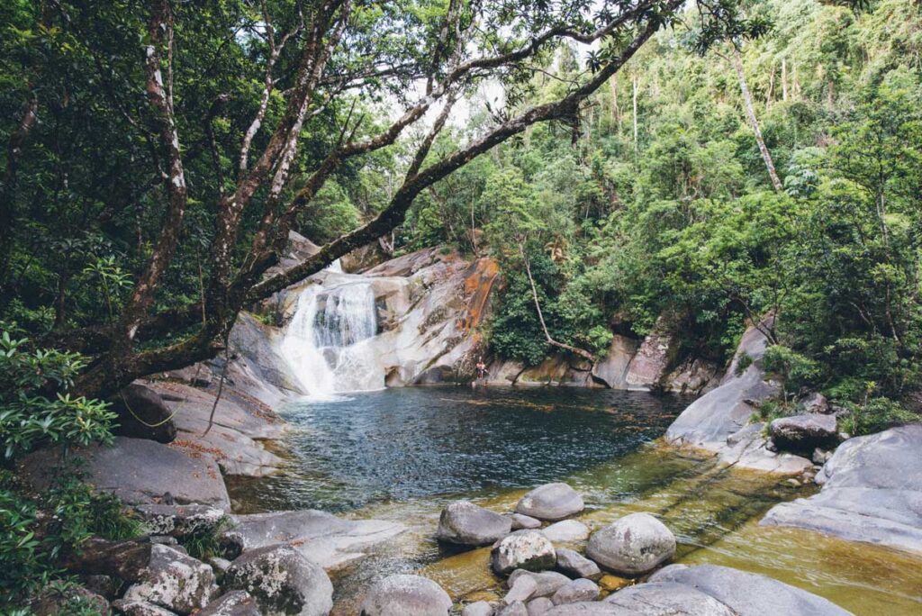
Josephine Falls is one of the most photogenic waterfalls in far north Queensland. Unlike other waterfalls, the impressiveness of this Queensland waterfall comes from cumulative effect rather than height or power.
Realistically, Josephine Falls is a cascade rather than a waterfall. It is the result of Josephine Creek tumbling over a series of big granite boulders. The water in Josephine Creek collects on Mount Bartle Frere – Queensland’s highest mountain – and eventually makes its way into the Russell River.
Five great things to do in Cairns
- 🐠 See marine wonders at two Outer Reef hotspots – on a Great Barrier Reef snorkelling cruise.
- 🌿 On a day trip – explore Mossman Gorge, Cape Tribulation and the Daintree Rainforest.
- 🚞 Combine the Kuranda Scenic Railway and Skyrail Rainforest Cableway – on a day trip to Kuranda.
- 🚣 On a full day rafting adventure – tackle the white water of the Tully River.
- 🌄 See giant trees, rainforest waterfalls and crater lakes – on an Atherton Tablelands day tour.
Where is Josephine Falls in far north Queensland?
Josephine Falls is in Wooroonooran National Park in far north Queensland. It’s about 7.5km from Mount Bartle Frere. The turn-off from the Bruce Highway for the Josephine Falls car park is between the towns of Innisfail and Babinda. From Cairns, it’s just over an hour’s drive.
Can you swim at Josephine Falls?
It is possible to swim in Josephine Creek at the bottom of Josephine Falls, but the Parks and Forests department strongly advises against it. The creek is prone to flash flooding, currents can be much stronger than they look and submerged objects pose serious hazards.
People have died here, as the website spells out in big, bold letters.
Josephine Falls walk and Mount Bartle Frere hike
You’re better off, therefore, sticking to walking. It’s a 1.2km walk from the car park to the Josephine Falls viewing platforms. This is pretty easy going and should take half an hour return. However, if you want to go the whole hog, you can make Josephine Falls a staging post on the hike to the summit of Mount Bartle Frere.
This is a serious, steep 30km return undertaking. It is best tackled over two days, camping out overnight.
Other waterfalls in far north Queensland
Other far north Queensland waterfalls include Nandroya Falls, Barron Falls, Tchupala Falls, and Windin Falls. Along the Palmerston Highway, you can combine Millaa Millaa Falls, Ellinjaa Falls and Zillie Falls in a handy 17km circuit. Near Mareeba, meanwhile, you can walk to Emerald Creek Falls and Davies Creek Falls.
Josephine Falls visitor information: Parking, opening hours and facilities
| Question | Answer |
|---|---|
| Where is Josephine Falls located? | In Wooroonooran National Park, between Innisfail and Babinda in far north Queensland |
| How far is Josephine Falls from Cairns? | Just over one hour by car |
| Is there parking at Josephine Falls? | Yes, parking is available at the Josephine Falls car park |
| Can you swim at Josephine Falls? | Swimming is possible, but strongly discouraged due to flash flooding and dangerous currents |
| How long is the Josephine Falls walk? | 1.2km return to the viewing platforms |
| How long does the Josephine Falls walk take? | Approximately 30 minutes return |
| Can you hike Mount Bartle Frere from Josephine Falls? | Yes, via a steep 30km return hike usually completed over two days |
More Queensland travel
Other Queensland travel articles on Planet Whitley include:
- Plan your visit to the Cairns Botanic Gardens.
- Skyrail Rainforest Cableway visitor guide: Plan your trip on Australia’s longest cable car ride.
- Kuranda attraction guides: Barron Falls, Birdworld Kuranda, Kuranda Koala Gardens, the Australian Butterfly Sanctuary and Rainforestation Nature Park.
- Exploring the Great Barrier Reef: Best islands and tours.
- Admire the magnificent Curtain Tree Fig in Yungaburra.