Crossing the Nullarbor from Adelaide to Perth turns out to be rather enjoyable if you make the right stops.
Five reasons to drive the Nullarbor
- Swimming with sea lions at Baird Bay.
- Standing on top of giant cliffs at Head of Bight.
- Telegraph history at Eucla.
- The quirky roadhouses every couple of hours
- The sense of challenge and embrace of the emptiness.
For a personal experience, read on.
Getting to know the sea lions of Baird Bay
It’s Beryl’s eyes that do it. If she asked for a pony, no-one would be able to refuse her. But she’s not pleading for anything – just curious.

Beryl is about three years old, and lives with around 140 friends and family on Jones Island off the Western Coast of South Australia’s Eyre Peninsula. She’s a rarity, too – there are only an estimated 10,000 Australian sea lions in the wild. And those in Baird Bay are almost certainly the friendliest.
This is largely down to Alan Payne, who has spent two-and-a-half decades bonding with the Jones Island colony. Alan moved to Baird Bay from Western Australia in 1992, started off doing fishing tours and gradually worked out that guests were more enthralled by the sea lions than the fish.
When he started swimming with them, they were a little stand-offish – apparently driving the boat within 100 metres of the beach would spook them a little. Now they merrily play around next to him, and whoever Baird Bay Experience has brought along for the ride.
On a cloudy day, though, it takes a while for the sea lions to get moving. A couple of pups splash around in the sea caves, an enormous bull just sits motionless on the rocks, and a pair of adolescent males play fight on the beach.
Swimming with sea lions in South Australia
Once the sun breaks through, however, several head to their favourite spot – a natural pool sheltered by rocks from the swells at the entrance to the bay.
They glide on up, almost to the point where their noses are nudging the snorkel mask. They swim underneath and back out on the other side. And they don’t half pose for the camera.
Their speed and agility is remarkable. They twist and turn in the water like dismounting gymnasts. They change angle and direction with astonishing dexterity. And they do backflips, breaching out of the water, to show off.
Beryl is the nosiest of them all, although she hasn’t always been sweetness and light. “We called her Beryl the feral,” says Alan. “She used to chew the living daylights out of me.”
Her personality has changed in recent months, to the point where she’s the most reliably friendly of the colony. “She’s a very special character,” says Alan, with an obvious fondness.
Crossing the Nullarbor
It’s a magical, touching experience that isn’t quite what I expected when setting out on the long, long drive from Adelaide to Perth. Tackled without diversions, it’s 2,693km, much of which is taken up by the dreaded Nullarbor Plain.

There are technical, geographical definitions of where the Nullarbor starts and ends, but the best rule of thumb definition is the mobile phone reception drop-out zone between Ceduna in South Australia and Kalgoorlie in Western Australia. That stretch? A mere 1,386km. And Baird Bay, a relatively trifling eight hour drive from Adelaide, is the treat before the challenge.
The traditional view of the Nullarbor is that it is a vast treeless plain, but that’s not entirely accurate.
Cactus Beach and Fowlers Bay
The first hour or so after leaving Ceduna is through the last remnants of wheat country, and a diversion off the Eyre Highway leads towards pink-tinged lakes and bright white sand dunes. The target here is Cactus Beach, which has near-mythical status amongst surfers. It’s wild, it’s isolated, and has beautifully consistent breaks. The basic campground behind the dunes fills with surfboard-toting campervans.
The next diversion is probably the most likable place to stay on the whole Nullarbor journey. Fowlers Bay, unlike most of the roadhouses on the route, feels like a sleepy coastal village. The world may have forgotten it, but there’s a café and a few holiday homes tucked behind the beach. Come the winter months, whale-watching tours leave from here. The wild white dunes stack up high to the side, and a series of signs tell the town’s history.

The cross-continental telegraph line
This was where the colonial-era explorer, John Edward Eyre, made his base camp in November 1840. His mission was to be first cross the Nullarbor. After desertions, and skirting perilously close to death, he made it, which later paved the way for the telegraph line that would stretch across the country. The final stretch of that was also connected in Fowlers Bay – a team of 38 men and 89 horses covered the gap between here and Eucla in Western Australia, starting in July 1876 and finishing a year later. The rudimentary road – later upgraded to the Eyre Highway – and railway line would follow.
It’s not long after Fowlers Bay that the predicted image of the Nullarbor emerges – the trees and wheatfields disappear, replaced by forlorn-looking scrub. The landscape is parched, with only saltbush showing any signs of resistance, and the road cuts through it, heading off into the empty horizon.
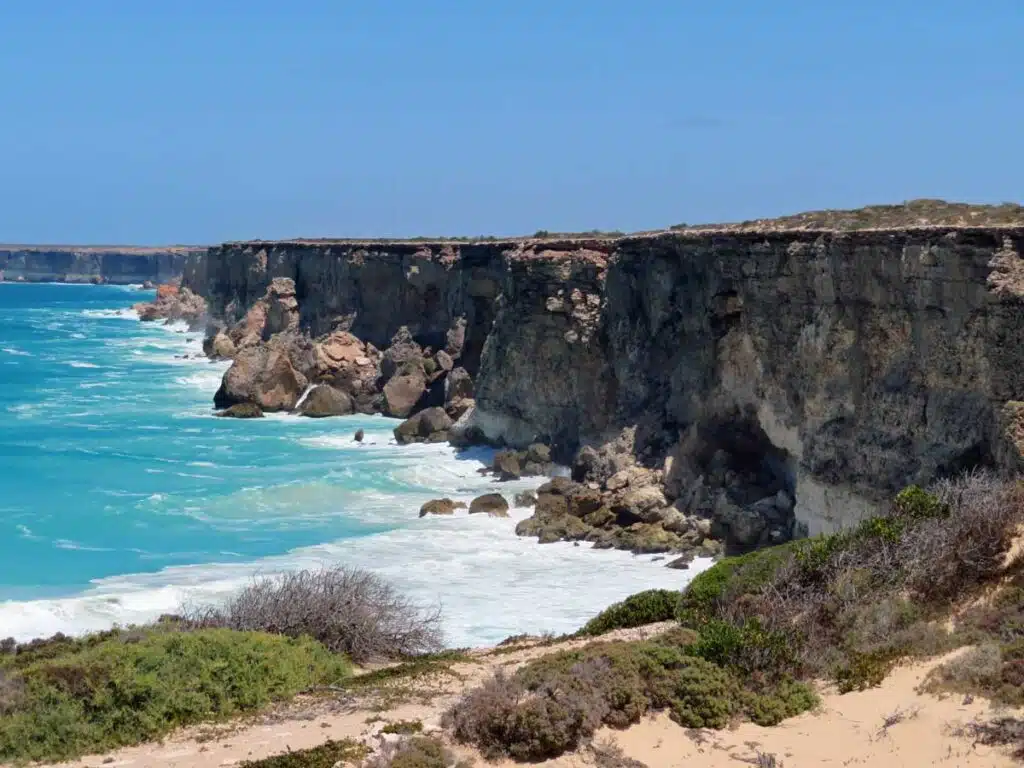
The giant cliffs at Head of Bight
But there’s another detour to make at the start of this: Head of Bight. This is where the divide between the true Nullarbor and the build-up is most distinct. Standing on the boardwalk, looking out for the southern right whales which regularly shelter here, the dunes pile up to the left, while to the right are hard, unrelenting towering cliffs. The join between the two worlds could not be more obvious, and it’s a beautiful spot.
The destruction of Ooldea’s water supply
The indigenous name for the Nullarbor was ‘Oondiri’, meaning waterless plain. The lack of water meant more than lack of trees, and with an average of eight inches of rain per year, it was too harsh for permanent settlement. Aboriginal people travelled across when water was accessible in rockholes, and the telegraph line was built along an ancient Aboriginal trade route.
As is so often the case in Australian history, the indigenous people were treated badly. When the Trans-Australia railway opened in 1915, the trains use 45,000 litres of water every day. This destroyed what was once a permanent source of water at Ooldea. A resource that had been used for centuries was wiped out almost overnight.
Life on the Nullarbor
The Head of Bight Visitor Centre plays host to more information about the Nullarbor Plain – a giant slab of limestone, riddled with caves and underground lakes. There is life here too – wombats burrow deep underground to escape the heat, red kangaroos bound instead of running on all fours.
The 23 native mammal species, 70 reptile species and 240 bird species may not be abundant, but there is life out here.
Beginning to enjoy the Nullarbor drive
And this becomes the theme of the long drive across the Nullarbor. The expectation that it will be a grim, tedious test of endurance doesn’t quite materialise.
The driving is easy-going – stick the car in cruise control and it’s pretty stress-free – and the supposed monotony regularly punctured by gradual changes in scenery and frequent quirks.

Nullarbor roadhouses and their gimmicks
Most of these come at the roadhouses that crop up every hour or two. They exist solely to refuel and accommodate drivers tackling the Nullarbor, and often have their own little gimmicks.
At Eucla, the first stop across the Western Australian border, there’s an old telegraph station, slowly decaying amongst the dunes. And, at Cocklebiddy, Samantha and Bruce, two wedge-tailed eagles that have been nursed back to health after being hit by cars, greet visitors.

Most impressive of all is Balladonia, where a small museum plays homage to the roadhouse’s unlikely moment in the global spotlight
Balladonia: Where Skylab crashed
In July 1979, the Skylab space station had gone rogue in an unstable orbit. It was going to fall to earth, bursting into fire and breaking up as it did so. When it was sent up in 1973, strapped to a Saturn V rocket, it was the largest thing human beings had ever shot into space. And if 77,000kg is going to fall from above, you sure as hell don’t want it to be over a big city.
Reading the newspaper clippings from the run-up to Skylab’s demise show how alarming it must have been. Diagrams were published with several possible paths – some heading safely over oceans, others going where an awful lot of destruction could ensue.
Eventually, NASA intervened, using what controls it had left to nudge the orbit, sending Skylab into a tumbling motion. The plan was for it to come down somewhere in the South Atlantic or Indian Ocean, well out of harm’s way.
The largest single chunk did, but much of the rest of the debris missed the target. Balladonia – population, 14 – was about to find itself at the centre of a global media circus.
Several pieces of the disintegrating space station landed nearby, and the roadhouse owner got a surprise phone call from US President Jimmy Carter apologising for any damage.
As Australian and American reporters trooped in, and other arrivals headed out through the rough scrub in their four wheel drive vehicles. They were hunting for parts of the wreckage, spurred on by the San Francisco Examiner. It’d had put up a $10,000 prize for the first person to bring a verifiable piece of Skylab to their office. This meant a frantic scramble to find what had fallen from the sky, and a race to get it on the plane to the States. In the end, a 17-year-old named Stan Thornton from Esperance won, but he had plenty of competition from eager treasure hunters bombing around bumpy sheep paddocks.

It comes as no surprise, therefore, to learn that the hunks of the space station inside the museum and on top of the roadhouse roof are replicas. All that’s left for Balladonia – which has long since faded back into obscurity – are the memories, and a lovingly-tended exhibition full of quirky details.
The Nullarbor Links golf course
It’s such quirky details that are brought to the fore in the Nullarbor’s most quixotic project – the Nullarbor Links golf course. The 18 holes stretch from Ceduna to Kalgoorlie, usually with one holes at each road house. Don’t expect the fairways to be in any sort of condition, but do take the time to read the signs next to the tee.
Each one tells a potted bit of history about the local area, whether saluting petrol tanker drivers who’ve ploughed the Nullarbor for decades or telling the tale of a German settler who abandoned a whaling ship then set up a farm in the middle of nowhere.
Things like this break up the drive, but the whole experience is much more than getting from A to B. Driving the Nullarbor is a rite of passage, and a contemplative journey through a land where the human touch is rarely apparent.
More Western Australia travel
Other Western Australia travel articles on Planet Whitley include:
- A tale of mutiny and murder on the Houtman Abrolhos Islands.
- 6 reasons to add Perth to your Australian holiday.
- Why you should see the Pinnacles at night.
- What it’s like to swim with whale sharks.
- Australia’s capital cities ranked.crocodiles in Australia?